
Annapurna Massif, Annapurna Basecamp
OpenTrip Annapurna, Pegunungan Himalaya
OpenTrip Annapurna, Pegunungan Himalaya
| Annapurna | |
|---|---|
.jpg)
South Face of Annapurna I (Main)
|
|
| Highest point | |
| Elevation | 8,091 m (26,545 ft) Ranked 10th |
| Prominence | 2,984 m (9,790 ft) [1][2] Ranked 100th |
| Isolation | 34 kilometres (21 mi) |
| Parent peak | Cho Oyu |
| Listing | Eight-thousander Ultra |
| Coordinates | 28°35′46″N 83°49′13″ECoordinates: 28°35′46″N 83°49′13″E |
| Geography | |

Annapurna
Nepal
|
|
| Location | Gandaki Zone, Nepal |
| Parent range | Himalayas |
| Climbing | |
| First ascent | 3 June 1950 Maurice Herzog and Louis Lachenal (First winter ascent 3 February 1987 Jerzy Kukuczka and Artur Hajzer) |
| Easiest route | northwest face |

The entire massif and surrounding area are protected within the 7,629 square kilometres (2,946 sq mi) Annapurna Conservation Area, the first and largest conservation area in Nepal. The Annapurna Conservation Area is home to several world-class treks, including Annapurna Sanctuary and Annapurna Circuit.
Historically, the Annapurna peaks are among the world's most dangerous mountains to climb, although in more recent history, using only figures from 1990 and after, Kangchenjunga has a higher fatality rate.[4] By March 2012, there had been 191 summit ascents of Annapurna I Main, and 61 climbing fatalities on the mountain.[5] This fatality-to-summit ratio (32%) is the highest of any of the eight-thousanders. In particular, the ascent via the south face is considered, by some, the most difficult of all climbs. In October 2014, at least 43 people were killed as a result of snowstorms and avalanches on and around Annapurna, in Nepal's worst ever trekking disaster.[6]
Annapurna is a Sanskrit name (fem.) that literally means "(She who is) Replete with food", but is normally translated as Goddess of the Harvests. According to Devdutt Pattanaik, Annapoorna devi is "... the universal and timeless kitchen-goddess ... the mother who feeds. Without her there is starvation, a universal fear: This makes Annapurna a universal goddess ... Her most popular shrine is located in Varanasi, on the banks of the Ganges River." Her association with the giving of food (wealth) led her in time to be transformed into Lakshmi, the Goddess of Wealth.[7]
Contents
Geography
The Annapurna massif contains six prominent peaks over 7,200 m (23,620 ft) elevation:
| Annapurna I (Main) | 8,091 m | (26,545 ft) Ranked 10th; Prominence=2,984 m | 28.595°N 83.819°E |
| Annapurna II | 7,937 m | (26,040 ft) Ranked 16th; Prominence=2,437 m | 28.539°N 84.137°E |
| Annapurna III | 7,555 m | (24,786 ft) Ranked 42nd; Prominence=703 m | 28.585°N 84.000°E |
| Annapurna IV | 7,525 m | (24,688 ft) | 28.539°N 84.087°E |
| Gangapurna | 7,455 m | (24,457 ft) Ranked 59th; Prominence=563 m | 28.606°N 83.965°E |
| Annapurna South | 7,219 m | (23,684 ft) Ranked 101st; Prominence=775 m | 28.518°N 83.806°E |
Less prominent and other peaks in the Annapurna Himal include:
- Annapurna I Central 8,051 m (26,414 ft)
- Annapurna I East 8,010 m (26,280 ft)
- Annapurna Fang 7,647 m (25,089 ft)
- Khangsar Kang 7,485 m (24,557 ft)
- Tarke Kang 7,202 m (23,629 ft)
- Lachenal Peak 7,140 m (23,425 ft)
- Tilicho Peak 7,135 m (23,409 ft)
- Nilgiri Himal North 7,061 m (23,166 ft), Central 6,940 m (22,769 ft) and South 6,839 m (22,438 ft)
- Machhapuchchhre 6,993 m (22,943 ft)
- Hiunchuli 6,441 m (21,132 ft)
- Gandharba Chuli 6,248 m (20,499 ft)

Climbing expeditions

The Annapurna massif, view from aircraft

The south face of Annapurna I

Reflection of Annapurna Dakshin (South) Mountain in fresh water
Annapurna I
Annapurna I was the first 8,000-metre (26,200 ft) peak to be climbed.[5] Maurice Herzog and Louis Lachenal, of a French expedition led by Herzog (including Lionel Terray, Gaston Rébuffat, Marcel Ichac, Jean Couzy, Marcel Schatz, Jacques Oudot, Francis de Noyelle), reached the summit on 3 June 1950.[8] Ichac made a documentary of the expedition, called Victoire sur l'Annapurna. Its summit was the highest summit attained for three years, until the first successful ascent of Mount Everest.
(However, higher non-summit points—at least 8,500 metres
(27,900 ft)—had already been attained on Everest in the 1920s.) However,
there is an argument that the 1920s attempt of Everest was successful
and if this is true the Annapurna ascent would have been the first time
people had survived an ascent of an eight-thousander.
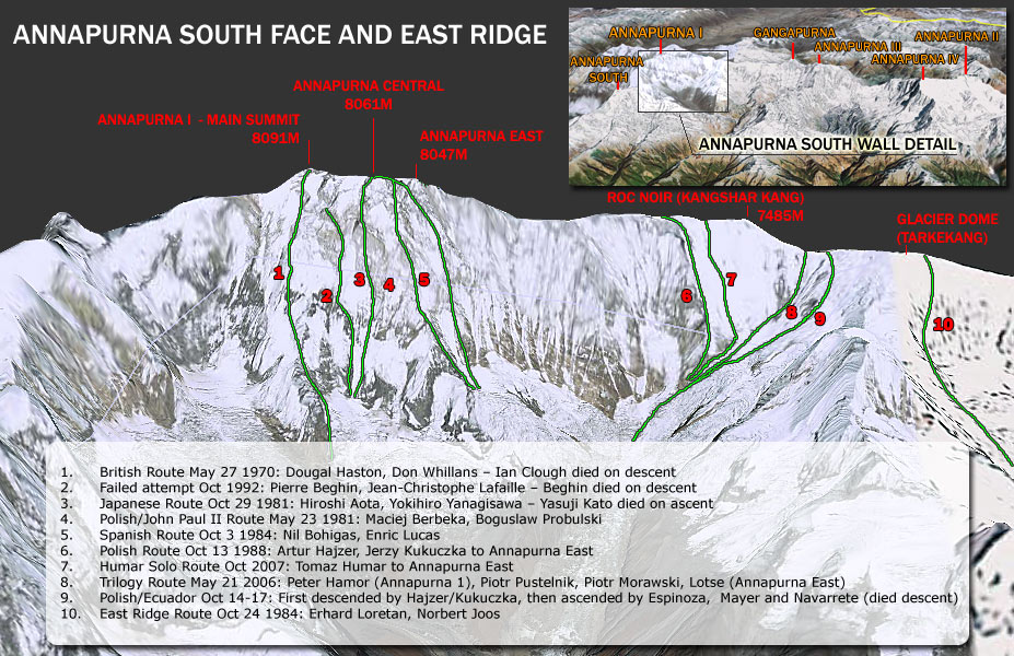
The south face of Annapurna was first climbed in 1970 by Don Whillans and Dougal Haston using supplementary oxygen, members of a British expedition led by Chris Bonington that included the alpinist Ian Clough, who was killed by a falling serac during the descent. They were, however, beaten to the second ascent of Annapurna by a matter of days by a British Army expedition led by Colonel Henry Day.
In 1978, the American Women's Himalayan Expedition, a team led by Arlene Blum, became the first United States team to climb Annapurna I. The first summit team, composed of Vera Komarkova and Irene Miller, and Sherpas
Mingma Tsering and Chewang Ringjing, reached the top at 3:30 pm on
October 15, 1978. The second summit team, Alison Chadwick-Onyszkiewicz
and Vera Watson, died during this climb.[9]
In 1981 Polish expedition Zakopane Alpine Club set a new route on Annapurna I Central (8051 m). Maciej Berbeka
and Bogusław Probulski reached the summit on May 23, 1981. The route
called Zakopiańczyków Way was recognized as the best achievement of the
Himalayan season in 1981.
On 3 February 1987, Polish climbers Jerzy Kukuczka and Artur Hajzer made the first winter ascent of Annapurna I.[10]
The first solo ascent of the south face was made in October 2007 by Slovenian climber Tomaž Humar;[11][12][13][14] he climbed to the Roc Noir and then to Annapurna East (8,047m).[15]
On 8 and 9 October 2013 Swiss climber Ueli Steck soloed the Lafaille route[15] on the main and highest part of the face;[16] this was his third attempt on the route and has been called "one of the most impressive Himalayan climbs in history",[17] with Steck taking 28 hours to make the trip from Base Camp to summit and back again.[18]

Annapurna from above
Fatality rate
Annapurna I has the greatest fatality rate of all the 14 eight-thousanders:
as of March 2012, there have been 52 deaths during ascents, 191
successful ascents, and nine deaths upon descent. The ratio of 34 deaths
per 100 safe returns on Annapurna I is followed by 29 for K2 and 21 for Nanga Parbat.[5] Climbers killed on the peak include Britons Ian Clough in 1970 and Alex MacIntyre in 1982, Frenchman Pierre Béghin in 1992, Russian Kazakh Anatoli Boukreev in 1997, Spaniard Iñaki Ochoa in 2008,[19] and Korean Park Young-seok, lost in 2011.[20]
The other peaks
|
|
This section does not cite any sources. (May 2017) (Learn how and when to remove this template message)
|
Gangapurna was first climbed in 1965 by a German expedition led by
Günther Hauser, via the East Ridge. The summit party comprised 11
members of the expedition.
Annapurna South
(also known as Annapurna Dakshin, or Moditse) was first climbed in 1964
by a Japanese expedition, via the North Ridge. The summit party
comprised S. Uyeo and Mingma Tsering.
Hiunchuli
(6,441 m/21,126 ft) is a satellite peak extending east from Annapurna
South, Hiunchuli was first climbed in 1971 by an expedition led by U.S.
Peace Corps Volunteer Craig Anderson.
Mount Machhapuchchhre
(6,993 m or 22,943 ft), named after its resemblance to a fish-tail, is
another important peak, though it just misses the 7,000 metre mark.
Mount Machhapuchchhre and Hiunchuli are prominently visible from the
valley of Pokhara. These peaks are the "gates" to the Annapurna Sanctuary
leading to the south face of Annapurna I. Mount Machhapuchchhre was
climbed in 1957 (except the final 50 metres for its local religious
sanctity) by Wilfrid Noyce and A. D. M. Cox. Since then it has been off limits.
Trekking
The Annapurna Conservation Area (7,629 km²) is a well known trekking region. There are three major trekking routes in the Annapurna region: the Jomson Trek to Jomsom and Muktinath (increasingly disturbed by a road-building project[21]); the Annapurna Sanctuary route to Annapurna base camp; and the Annapurna Circuit, which circles the Annapurna Himal itself and includes the Jomsom route.[22] The town of Pokhara
usually serves as a starting point for these treks, and is also a good
starting place for other short treks of one to four days, such as routes
to Ghorepani or Ghandruk.
The Mustang
district, a former kingdom bordering Tibet, is also geographically a
part of the Annapurna region, but treks to upper Mustang are subject to
special restrictions. Mustang is also increasingly becoming popular for
mountain biking because of the construction of roads undertaken by the
Nepali government in the region.
About two-thirds of all trekkers in Nepal visit the Annapurna region.
The area is easily accessible, guest houses in the hills are plentiful,
and treks here offer incredibly diverse scenery, with both high
mountains and lowland villages. Also, because the entire area is
inhabited, trekking in the region offers unique cultural exposure and
experience.[23][24]
2014 trekking disaster
In October 2014, at least 43 people were killed, and some 175
injured, as a result of snowstorms and avalanches on and around
Annapurna, including trekkers from Nepal, Israel, Canada, India,
Slovakia and Poland. Between 10 and 50 people were thought likely to be
missing.[25][26] It was believed that about 100 trekkers had left a guest house at 4,800 metres (15,700 ft), to climb to the top of Thorong La pass and then descend.[26]
The authorities were criticized for not giving sufficient warning of the approaching bad weather.[26]
By 18 October, some 289 people were reported as having been rescued. An
official from the Nepal Ministry of Tourism said on 18 October that
helicopters were looking for survivors and bodies in snowy areas at up
to 5,790 metres (19,000 ft), and were trying to reach 22 hikers stranded
at Thorong La. The incident was said to be Nepal's worst-ever trekking
disaster.[6]
Gallery
-
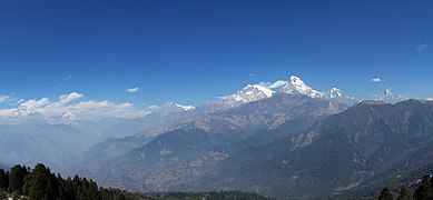 The Annapurna massif, seen from Poon Hill
-
 South face of Annapurna South
-
 South face of Annapurna South
-
 South face of Annapurna South
-
 South face of Annapurna South
-
 South face of Annapurna South
-
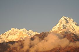
 Morning view of Annapurna I South Face from Annapurna Base Camp
-
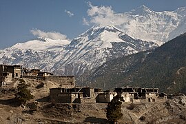 Bragha, Annapurna2
-
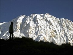 Annapurna south face
-
 Millet fields in the Annapurna region play a major part in local agriculture.
-
 Marsyangdi Valley

.JPG)
.JPG)
.JPG)
.JPG)
.JPG)

.jpg)


See also
References
- "Nepal blizzard: survivor tells of friends' deaths on Annapurna circuit". The Guardian. 16 October 2014.
Bibliography
- Blum, Arlene (1980). Annapurna: A Woman's Place. San Francisco, CA: Sierra Club Books. ISBN 0-87156-236-7.
- Herzog, Maurice (1951). Annapurna: First Conquest of an 8000-meter Peak. Translated by Nea Morin; Janet Adam Smith. New York: E.P Dutton & Co.
- Pattanaik, Devdutt (2009). 7 Secrets from Hindu Calendar Art. Westland. ISBN 978-81-89975-67-8.
Further reading
- Herzog, Maurice (1952). Annapurna. Jonathan Cape.
- Neate, Jill. High Asia: An Illustrated History of the 7000 Metre Peaks. Mountaineers Books. ISBN 0-89886-238-8.
- Ohmori, Koichiro (1998). Over the Himalaya. Cloudcap Press. ISBN 0-938567-37-3.
- Terray, Lionel (1963). Conquistadors of the Useless. Victor Gollancz Ltd. ISBN 0-89886-778-9. Chapter 7.
External links
| Wikimedia Commons has media related to Annapurna. |
- "Annapurna". Himalaya-Info.org (in German).
- "Annapurna". Summitpost.
Call Center ExploreWisata.com,
085.643.455.685
D72E559E / 7A722B86
Instagram : instagram.com/xplore.wisata
Instagram : instagram.com/xplore.gunung
Instagram : instagram.com/syarifain
Fanspage Umum : facebook.com/xplore.wisata
Fanspage Gunung : facebook.com/xplore.gunung
Website :
Instagram : instagram.com/xplore.gunung
Instagram : instagram.com/syarifain
Fanspage Umum : facebook.com/xplore.wisata
Fanspage Gunung : facebook.com/xplore.gunung
Website :
#porter #guide #pemandu #transport lokal #rinjani 3.726 mdpl #semeru 3.676 mdpl #slamet 3.428 mdpl #lawu 3.265 mdpl #merbabu 3.145 mdpl #sindoro 3.150 mdpl #gunungprau 2.565 mdpl #gunungsikunir #porterrinjani #portersemeru #porterargopuro #portermerbabu #porterlawu #porterslamet #portersumbing #portersindoro #kaosadventure #kaosbacpacker #backpackerindonesia #opentripsemeru #opentripmerbabu #opentripkarimunjawa #opentriprinjani #cikuray #gede #parango #gunungsalak #bromo #karimunjawa #guapindul #raftingsungaielo #raftingelo #raftingprogo #tangkubanperahu
#derawan #belitung #pahawang #cartensz piramid, #trekkingcartensz #cartenz murah #sevensummit